Over my writing career, I got to review a lot of different navigation programs. They were especially popular on the Windows Mobile platform. Among them, one of my all-time favorites was iGo (released in North America as OnCourse Navigator).
Now iGo is available on the iPhone. It’s been modified a little, keeping in line with their “My Way” PNA (personal navigation appliance/assistant) devices. It’s grown a little, changed a little and been fitted to take advantage of some of the iPhone’s features and characteristics.
Although it’s been largely ignored by a lot of reviewers, especially in North America (where the iGo name isn’t as well known), we’re going take a look at it here. How does it stack up to the current crop of iPhone navigation apps, including biggies like Navigon? Read on!
As I just mentioned, iGo for the iPhone is very much in line with iGo’s PNA offerings and it resembles them much more than it does the previous iGo 8 software. Following the “less is more” trend of most navigation software, the main screens are very clean, with very few visual elements, and very finger friendly.
iGo starts up fairly quickly and bring you into a main menu type of screen where you see a small window onto your map (which is the “button” to take you to your map – very clever) as well as some other primary options for setting your destination, working with your route (if one was previously set) and a “Settings” button.


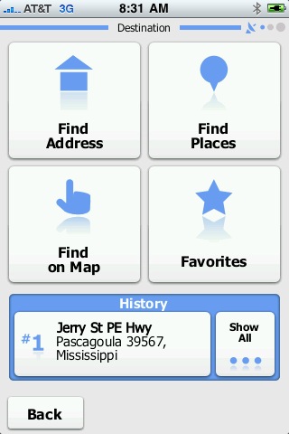
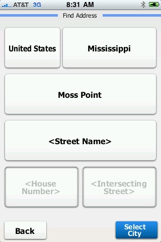
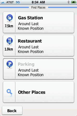
As with most current navigation applications, the program uses your current GPS position as your starting point. You set your destination by tapping the “Destination” button which takes you to a screen with a lot of different options for determining your destination including the standard “Find an Address”, “Find Places” (search points of interest – POIs), “Find on Map ” (manually search), “Favorites”, and then on the bottom is the last location you traveled to along with a “Show All” (history) button.

On a small side trip, this is a good time to mention that iGo is produced by a company called Nav-n-Go, which, in turn, was formed out of a game production company called PDAMill. That gaming history has always shown up in their navigation applications in little ways – usually in the use of excellent graphics and little animations. This version is no different in that tapping on a menu option or tapping to go to the map triggers some kind of transition – a slide or wipe or a zoom. This always gives iGo applications a kind of smoothness and flow that I don’t see in other programs. You might not even notice it at first, but I’ve always appreciated those little touches.
Once your selection is set, you press the button in the lower right corner of the screen and it shows you the routing options being applied then takes you a route summary screen. From this screen you can change those routing options, zoom in and out to see the whole route or just your destination. You can also change a variety of things about your route and the assumptions the program is making. You can change your vehicle type (within “Route Settings”). You can change whether the route should be the fastest, or shortest, easiest, or most economical (within “More Options”). When you are ready to go just press the big GO! button in the lower right corner.
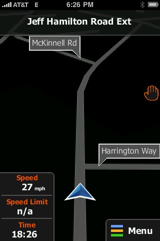
Navigation with this application is easy – the buttons and instructions are clear and easy to follow. The program lacks full TTS – typical on the iPhone right now – put it’s promised soon. You’ll notice that there’s a big “hand” icon on the right side of the screen. This is for panning around the map display at your current position. Nothing more.
When you press the “hand” icon you will see a variety of controls to pan and zoom the map display so you can see what’s around your position. When you are done, simply press the “Back” button to return to the navigation display.
While navigating, you may need to tweak what’s going on. iGo puts these kids of options into a “Quick Menu”. From here you can get more information about your present location, change the 2D/3D setting of the display, change your zoom level and perspective, or change the day/night color settings. Here I want to note a couple of things. First, the day/night setting, when set to “auto” uses your GPS position and time zone to determine when it should switch. Unfortunately, this function isn’t working correctly for me. It switches a few of hours too early. Secondly, the zoom choices are very limited. None of them are exactly what I’d like to see. What I’d really like is if they allowed me to use the pan/zoom display controls and then have a “SET” button so I could make that the perspective I wanted to use as my default. This lack of being able to set perspective is something that most of the current crop of navigation applications seem to share. It seems to be a victim of making the programs easier to navigate and use.

Routing selection was on par with other navigation apps out there, and is modified by making one of the routing type selections mentioned earlier. Recalculation times, even on long routes, was very reasonable.
There is included one “cute” feature. You can set you icon to one of a few available built-in icons, including a variety of vehicles and even a pedestrian. Each is presented to you in a little showroom for your selection!
Finally, we come to the “star” feature of this application – its 3D landscape and landmarks. This is a really cool feature. Today, it’s a bit of a novelty, but still very useful where they exist. The application has a database of locations, primarily in big cities, where it will show you 3D rendering of key buildings and landmarks on the map. They go translucent/transparent as you pass close so you can see upcoming buildings/streets/etc.
Additionally, elevations, are displayed on the screen – not the numerical value, but rather you see elevation visually – by color shadings. 3D really means 3D. It’s very nice, and better than I’ve seen in competing applications. By the way – numerical elevation (altitude) information is available via the “Quick Menu” mentioned before – simply hit the “Where Am I?” button.
What I Liked: I like the open, clean look of the display. I love the smooth transitions and organic feel of the application. I love the 3D graphics and I think that iGo has the best rendering engine out there.
What Needs Improvement:The lack of waypoints or road avoidance is disappointing. Small glitches like the day/night clock kicking in at the wrong time for my time zone needs to be corrected. I’d like to see a little smoother operation in the 3D landmark implementation on the iPhone. I’d also like more flexible options for setting my viewing perspective – a complaint I have with nearly every one of the current crop of navigation applications. Some apps have a “Call POI” feature – this one does not, but that may or may not be a big concern for you – for me it is not.
Overall: iGo was, and still, is one of my favorite navigation applications. It offers true 3D representation, including landscape and 3D landmarks, something no one else offers yet. With full TTS coming soon, iGo offers an excellent package and has perhaps the strongest core rendering base of all the available choices. If they had included waypoints and road avoidance/detouring, they would be my number one choice without a doubt. As is, they are in a close race with Navigon, with each offering features the other lacks. Watch this one closely folks! Available at the AppStore in versions for North America ($79.99), Western Europe ($89.99), and full Europe ($119.99).
UPDATE: I asked the folks that make iGo about some of the features that are not currently available and I wa notified that TTS (text-to-speech) is in the pipeline, stop-overs are due for the next update, and road avoidance/detours are planned for a future update!

Check out this new review: http://bit.ly/13YAgR
Enjoy!